

Hardware components | ||||||
_ztBMuBhMHo.jpg?auto=compress%2Cformat&w=48&h=48&fit=fill&bg=ffffff) |
| × | 1 | |||
 |
| × | 1 | |||
 |
| × | 1 | |||
| × | 1 | ||||
| × | 1 | ||||
Hand tools and fabrication machines | ||||||
 |
| |||||
 |
| |||||
 |
| |||||
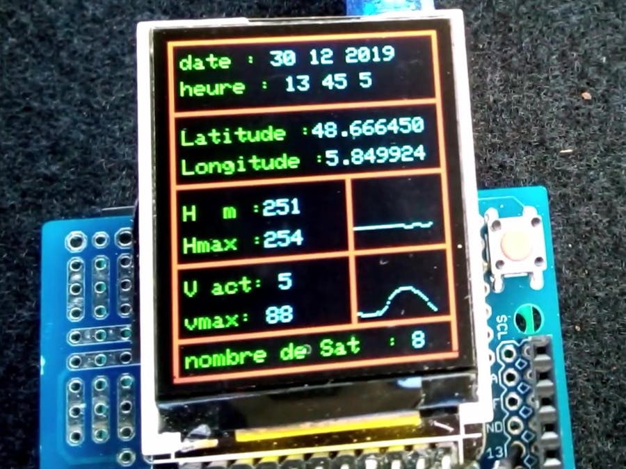
I practice aeromodelling and I like to know the speed and altitude of my planes. unfortunately, commercial GPS data loggers are very expensive.
So I decided to make a GPS data logger based on Arduino for a cost less than 50€.
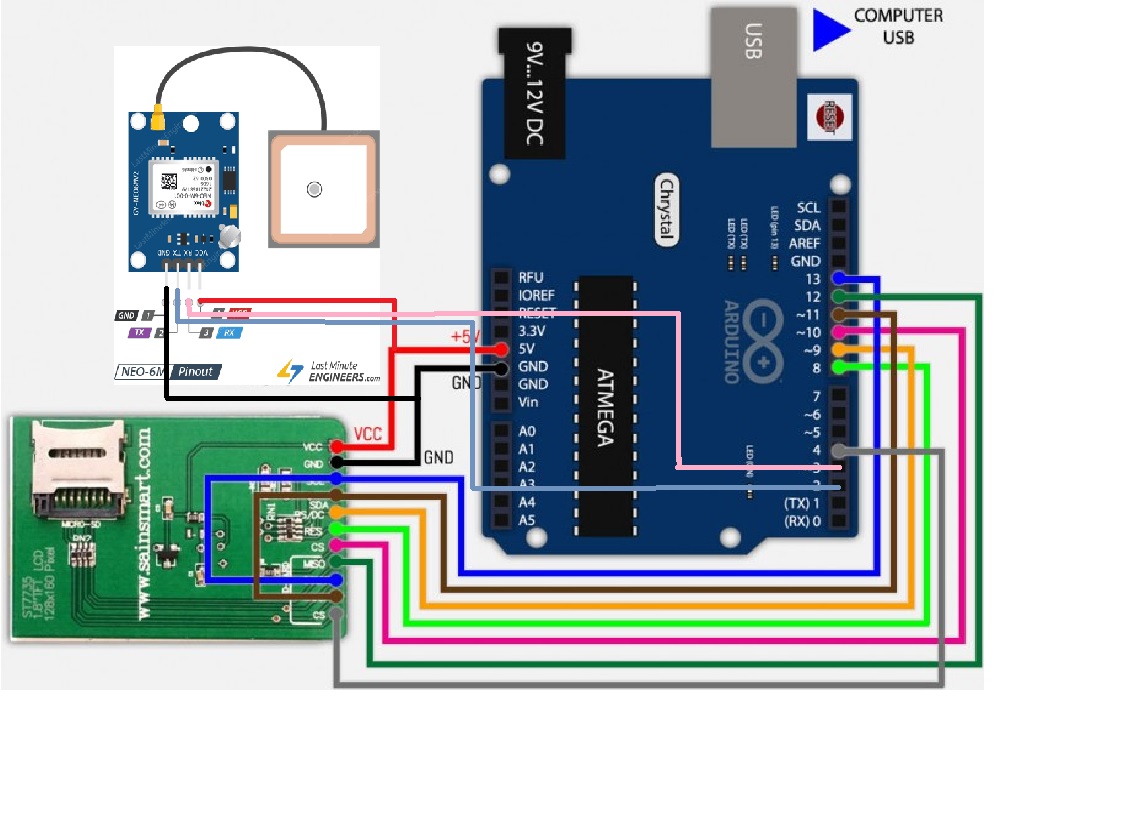
My first prototype is based on Arduino Uno R3 with a Sainsmart ST7735 screen with integrated SD card and a NEO 6M V2 GPS module.
In the second project I would use an Arduino Nano with an SSD1306 OLED screen, the same GPS module, and a micro SD card. The weight with case should be around 40 grams and can easily be integrated into a medium-sized aircraft (size L 50 mm X l 30mm X H 22mm).
It will be my next project (I'm waiting for the materials.)
TESTIt's not easy to film a screen of Arduino in a car, but I did it and you can see the result on the video.
The next test will be with the new, smaller and lighter prototype on a radio-controlled aircraft. To be continued!

#include <SPI.h>
#include <Adafruit_GFX.h>
#include <Adafruit_ST7735.h>
#define cs   10
#define dc   9
#define rst  8
#include <TinyGPS++.h>
#include <SoftwareSerial.h>
Adafruit_ST7735 tft = Adafruit_ST7735(cs, dc, rst);
static const int RXPin = 4, TXPin = 3; //GPS communication
static const uint32_t GPSBaud = 9600;

#define OLED_RESET 5


TinyGPSPlus gps;
SoftwareSerial ss(RXPin, TXPin);

int x=80;
int xh=80;
int maxhigh=0;
int maxspeed = 0, speed1 = 0;
int high1 = 0;;


void setup()
{

 Serial.begin(9600);
  ss.begin(GPSBaud);

  tft.initR(INITR_GREENTAB);
  tft.fillScreen(ST7735_BLACK);
  tft.setCursor(5, 58);
  tft.setTextSize(1);
  tft.setTextColor(ST7735_GREEN,ST7735_BLACK);
      tft.print("initilisation");


}

void loop()
{

	  tft.setTextSize(1);
  tft.setTextColor(ST7735_GREEN,ST7735_BLACK);

  // affichage des informations a chaque bonne reception satellite
  while (ss.available() > 0){
    gps.encode(ss.read());
    if (gps.location.isUpdated()){

    cadre();


       tft.setCursor(5, 44);
       tft.setTextColor(ST7735_GREEN,ST7735_BLACK);
      tft.print("Latitude :");
      tft.setTextColor(ST7735_CYAN,ST7735_BLACK);
      tft.print(gps.location.lat(), 6);
       tft.setCursor(5, 58);
       tft.setTextColor(ST7735_GREEN,ST7735_BLACK);
      tft.print("Longitude :");
      tft.setTextColor(ST7735_CYAN,ST7735_BLACK);
      tft.print(gps.location.lng(), 6);


       //affichage ecran date
      tft.setCursor(5, 7);
      tft.setTextColor(ST7735_GREEN,ST7735_BLACK);
      tft.print("date : ");
      tft.setTextColor(ST7735_CYAN,ST7735_BLACK);
      tft.print(gps.date.day());
      tft.print(" ");
      tft.print(gps.date.month());
      tft.print(" ");
      tft.print(gps.date.year());


      //affichage ecran heure
      tft.setCursor(5, 20);
       tft.setTextColor(ST7735_GREEN,ST7735_BLACK);
      tft.print("heure : ");
      tft.setTextColor(ST7735_CYAN,ST7735_BLACK);
      tft.print(gps.time.hour()+1);
      tft.print(" ");
      tft.print(gps.time.minute());
      tft.print(" ");
      tft.print(gps.time.second());
      tft.print(" ");
       tft.setTextColor(ST7735_GREEN,ST7735_BLACK);
        tft.setCursor(3, 30);


       //affichage ecran altitude
      tft.setCursor(5, 80);
      tft.print("H  m :");
      tft.setTextColor(ST7735_CYAN,ST7735_BLACK);
      tft.print (gps.altitude.meters(),0);
      tft.setTextColor(ST7735_CYAN,ST7735_BLACK);
      tft.print("   ");
      tft.setTextColor(ST7735_GREEN,ST7735_BLACK);
      tft.setCursor(5, 95);
      hmax();
      tft.print("Hmax :");
      tft.setTextColor(ST7735_CYAN,ST7735_BLACK);
      tft.print(maxhigh);
      tft.setTextColor(ST7735_CYAN,ST7735_BLACK);
      tft.print("   ");
      courbeh();


      //affichage ecran vitesse
       tft.setCursor(5, 115);
       tft.setTextColor(ST7735_GREEN,ST7735_BLACK);
      tft.print("V act: ");
      tft.setTextColor(ST7735_CYAN,ST7735_BLACK);
      tft.print (gps.speed.kmph(),0);
      tft.setTextColor(ST7735_CYAN,ST7735_BLACK);
      tft.print("   ");
      tft.setCursor(5, 130);
      tft.setTextColor(ST7735_GREEN,ST7735_BLACK);
      vmax();
      tft.print("vmax: ");
      tft.setTextColor(ST7735_CYAN,ST7735_BLACK);
      tft.print(maxspeed);
      tft.setTextColor(ST7735_CYAN,ST7735_BLACK);
      tft.print("   ");
      tft.setTextColor(ST7735_GREEN,ST7735_BLACK);
      courbe();


       //affichage ecran nombre de satellites
      tft.setCursor(5, 147);
      tft.setTextColor(ST7735_GREEN,ST7735_BLACK);
      tft.print("nombre de Sat  : ");
      tft.setTextColor(ST7735_CYAN,ST7735_BLACK);
      tft.print(gps.satellites.value());
      tft.setTextColor(ST7735_CYAN,ST7735_BLACK);
      tft.print("   ");

      // Horizontal Dim. of Precision (100ths-i32)
      Serial.print("HDOP = ");
      Serial.println(gps.hdop.value());


  smartDelay(400);


}
  }
}
// delai pour une bonne recption
static void smartDelay(unsigned long ms)
{
  unsigned long start = millis();
  do
  {
    while (ss.available())
      gps.encode(ss.read());
  } while (millis() - start < ms);
}
void cadre() {
  // affichage ecran
       //cadre
       tft.drawLine(0,0,130,0,ST7735_RED);
       tft.drawLine(0,1,130,1,ST7735_RED);
       tft.drawLine(0,158,130,158,ST7735_RED);
       tft.drawLine(0,142,130,142,ST7735_RED);
       tft.drawLine(0,141,130,141,ST7735_RED);
       tft.drawLine(0,107,130,107,ST7735_RED);
       tft.drawLine(0,108,130,108,ST7735_RED);

       tft.drawLine(80,108,80,140,ST7735_RED);
       tft.drawLine(81,109,81,140,ST7735_RED);

       tft.drawLine(80,70,80,108,ST7735_RED);
       tft.drawLine(81,70,81,108,ST7735_RED);

       tft.drawLine(0,159,130,159,ST7735_RED);
        tft.drawLine(0,0,0,156,ST7735_RED);
       tft.drawLine(1,1,1,157,ST7735_RED);
       tft.drawLine(127,0,127,156,ST7735_RED);
       tft.drawLine(126,0,126,156,ST7735_RED);
       tft.drawLine(0,35,130,35,ST7735_RED);
       tft.drawLine(0,36,130,36,ST7735_RED);
       tft.drawLine(0,70,130,70,ST7735_RED);
       tft.drawLine(0,71,130,71,ST7735_RED);

}

void courbe() {


  int nouvelleValeur;

  // converison vitesse max (350 km/h) en pixel
  nouvelleValeur = map((gps.speed.kmph()), 0, 150, 137, 110); // car l'cran a 64 pixels de haut


  x++;

  tft.drawPixel(x,nouvelleValeur,ST7735_CYAN);
  if (x>123) {
    x=80;
    tft.fillRect(82,110,43,30,ST7735_BLACK);

  }
}
void courbeh() {


  int nouvelleValeurh;

  // converison vitesse max (350 km/h) en pixel
  nouvelleValeurh = map((gps.altitude.meters()), 0, 1000, 104, 72); // car l'cran a 64 pixels de haut


  xh++;

  tft.drawPixel(xh,nouvelleValeurh,ST7735_CYAN);
  if (xh>123) {
    xh=80;
    tft.fillRect(82,72,43,35,ST7735_BLACK);

  }
}
void vmax() {
// calcul vitese maximum
      speed1 = (gps.speed.kmph());
         if ( speed1 > maxspeed) {
         maxspeed = speed1;
      }
  }
   void hmax() {
//      calcul altitude maximum
      high1 = (gps.altitude.meters());
          if ( high1 > maxhigh) {
        maxhigh = high1;
      }
   }
#include <SPI.h>
#include<SD.h>
#include <Adafruit_GFX.h>
#include <Adafruit_ST7735.h>
#define cs   10
#define dc   9
#define rst  8
#include <TinyGPS++.h>
#include <SoftwareSerial.h>
Adafruit_ST7735 tft = Adafruit_ST7735(cs, dc, rst);
static const int RXPin = 4, TXPin = 3; //GPS communication
static const uint32_t GPSBaud = 9600;
const int cs_sd=4;
#define OLED_RESET 5


TinyGPSPlus gps;
SoftwareSerial ss(RXPin, TXPin);

int x=80;
int xh=80;
int maxhigh=0;
int maxspeed = 0, speed1 = 0;
int high1 = 0;;


void setup()
{

 Serial.begin(9600);
  ss.begin(GPSBaud);
  tft.initR(INITR_GREENTAB);
  tft.fillScreen(ST7735_BLACK);
  tft.setCursor(5, 58);
  tft.setTextSize(1);
      tft.setTextColor(ST7735_GREEN,ST7735_BLACK);
      tft.print("initilisation");
      tft.setCursor(5, 70);
  tft.print("init SD");
  delay(1000);
  if(!SD.begin(cs_sd))    //Condition vrifiant si la carte SD est prsente dans l'appareil
  {
    tft.setCursor(5, 82);
    tft.print("Defaut SD");
    return;
  }
  tft.setCursor(5, 82);
  tft.print("Carte SD OK");

  delay(1000);
  tft.fillScreen(ST7735_BLACK);

  File data = SD.open("donnees.txt",FILE_WRITE);              // Ouvre le fichier "donnees.txt"
  data.println(""); data.println("Dmarrage acquisition");    // Ecrit dans ce fichier
  data.close();


}

void loop()
{

	  tft.setTextSize(1);
  tft.setTextColor(ST7735_GREEN,ST7735_BLACK);

  // affichage des informations a chaque bonne reception satellite
  while (ss.available() > 0){
    gps.encode(ss.read());
    if (gps.location.isUpdated()){

    cadre();


       tft.setCursor(5, 44);
       tft.setTextColor(ST7735_GREEN,ST7735_BLACK);
      tft.print("Latitude :");
      tft.setTextColor(ST7735_CYAN,ST7735_BLACK);
      tft.print(gps.location.lat(), 6);
       tft.setCursor(5, 58);
       tft.setTextColor(ST7735_GREEN,ST7735_BLACK);
      tft.print("Longitude :");
      tft.setTextColor(ST7735_CYAN,ST7735_BLACK);
      tft.print(gps.location.lng(), 6);


       //affichage ecran date
      tft.setCursor(5, 7);
      tft.setTextColor(ST7735_GREEN,ST7735_BLACK);
      tft.print("date : ");
      tft.setTextColor(ST7735_CYAN,ST7735_BLACK);
      tft.print(gps.date.day());
      tft.print(" ");
      tft.print(gps.date.month());
      tft.print(" ");
      tft.print(gps.date.year());

      String Date=String(gps.date.day())+(" ")+(gps.date.month())+(" ")+(gps.date.year());


      //affichage ecran heure
      tft.setCursor(5, 20);
       tft.setTextColor(ST7735_GREEN,ST7735_BLACK);
      tft.print("heure : ");
      tft.setTextColor(ST7735_CYAN,ST7735_BLACK);
      tft.print(gps.time.hour()+1);
      tft.print(" ");
      tft.print(gps.time.minute());
      tft.print(" ");
      tft.print(gps.time.second());
      tft.print(" ");
       tft.setTextColor(ST7735_GREEN,ST7735_BLACK);
        tft.setCursor(3, 30);

       String Temps=String(gps.time.hour()+1)+(" ")+(gps.time.minute())+(" ")+(gps.time.second());


       //affichage ecran altitude
      tft.setCursor(5, 80);
      tft.print("H  m :");
      tft.setTextColor(ST7735_CYAN,ST7735_BLACK);
      tft.print (gps.altitude.meters(),0);
      tft.setTextColor(ST7735_CYAN,ST7735_BLACK);
      tft.print("   ");
      tft.setTextColor(ST7735_GREEN,ST7735_BLACK);
      tft.setCursor(5, 95);
      hmax();
      tft.print("Hmax :");
      tft.setTextColor(ST7735_CYAN,ST7735_BLACK);
      tft.print(maxhigh);
      tft.setTextColor(ST7735_CYAN,ST7735_BLACK);
      tft.print("   ");
      courbeh();


      //affichage ecran vitesse
       tft.setCursor(5, 115);
       tft.setTextColor(ST7735_GREEN,ST7735_BLACK);
      tft.print("V act: ");
      tft.setTextColor(ST7735_CYAN,ST7735_BLACK);
      tft.print (gps.speed.kmph(),0);
      tft.setTextColor(ST7735_CYAN,ST7735_BLACK);
      tft.print("   ");
      tft.setCursor(5, 130);
      tft.setTextColor(ST7735_GREEN,ST7735_BLACK);
      vmax();
      tft.print("vmax: ");
      tft.setTextColor(ST7735_CYAN,ST7735_BLACK);
      tft.print(maxspeed);
      tft.setTextColor(ST7735_CYAN,ST7735_BLACK);
      tft.print("   ");
      tft.setTextColor(ST7735_GREEN,ST7735_BLACK);
      courbe();


       //affichage ecran nombre de satellites
      tft.setCursor(5, 147);
      tft.setTextColor(ST7735_GREEN,ST7735_BLACK);
      tft.print("nombre de Sat  : ");
      tft.setTextColor(ST7735_CYAN,ST7735_BLACK);
      tft.print(gps.satellites.value());
      tft.setTextColor(ST7735_CYAN,ST7735_BLACK);
      tft.print("  ");

      // Horizontal Dim. of Precision (100ths-i32)
      Serial.print("HDOP = ");
      Serial.println(gps.hdop.value());


  smartDelay(400);

 // Ecriture des donnes dans le fichier texte
  File data=SD.open("donnees.txt",FILE_WRITE);
  data.println(Date + " " + Temps + " " + String(gps.location.lat(), 6)+" "+String(gps.location.lng(), 6)+(" ")+String(gps.altitude.meters(),0)+(" ")+String(maxhigh)+(" ")+String(gps.speed.kmph(),0)+(" ")+String(maxspeed));
  data.close();

}
  }
}
// delai pour une bonne recption
static void smartDelay(unsigned long ms)
{
  unsigned long start = millis();
  do
  {
    while (ss.available())
      gps.encode(ss.read());
  } while (millis() - start < ms);
}
void cadre() {
  // affichage ecran
       //cadre
       tft.drawLine(0,0,130,0,ST7735_RED);
       tft.drawLine(0,1,130,1,ST7735_RED);
       tft.drawLine(0,158,130,158,ST7735_RED);
       tft.drawLine(0,142,130,142,ST7735_RED);
       tft.drawLine(0,141,130,141,ST7735_RED);
       tft.drawLine(0,107,130,107,ST7735_RED);
       tft.drawLine(0,108,130,108,ST7735_RED);

       tft.drawLine(80,108,80,140,ST7735_RED);
       tft.drawLine(81,109,81,140,ST7735_RED);

       tft.drawLine(80,70,80,108,ST7735_RED);
       tft.drawLine(81,70,81,108,ST7735_RED);

       tft.drawLine(0,159,130,159,ST7735_RED);
        tft.drawLine(0,0,0,156,ST7735_RED);
       tft.drawLine(1,1,1,157,ST7735_RED);
       tft.drawLine(127,0,127,156,ST7735_RED);
       tft.drawLine(126,0,126,156,ST7735_RED);
       tft.drawLine(0,35,130,35,ST7735_RED);
       tft.drawLine(0,36,130,36,ST7735_RED);
       tft.drawLine(0,70,130,70,ST7735_RED);
       tft.drawLine(0,71,130,71,ST7735_RED);

}

void courbe() {


  int nouvelleValeur;

  // converison vitesse max (350 km/h) en pixel
  nouvelleValeur = map((gps.speed.kmph()), 0, 150, 137, 110); // car l'cran a 64 pixels de haut


  x++;

  tft.drawPixel(x,nouvelleValeur,ST7735_CYAN);
  if (x>123) {
    x=80;
    tft.fillRect(82,110,43,30,ST7735_BLACK);

  }
}
void courbeh() {


  int nouvelleValeurh;

  // converison vitesse max (350 km/h) en pixel
  nouvelleValeurh = map((gps.altitude.meters()), 0, 1000, 104, 72); // car l'cran a 64 pixels de haut


  xh++;

  tft.drawPixel(xh,nouvelleValeurh,ST7735_CYAN);
  if (xh>123) {
    xh=80;
    tft.fillRect(82,72,43,35,ST7735_BLACK);

  }
}
void vmax() {
// calcul vitese maximum
      speed1 = (gps.speed.kmph());
         if ( speed1 > maxspeed) {
         maxspeed = speed1;
      }
  }
   void hmax() {
//      calcul altitude maximum
      high1 = (gps.altitude.meters());
          if ( high1 > maxhigh) {
        maxhigh = high1;
      }
   }


Comments