

Hardware components | ||||||
| × | 1 | ||||
| × | 1 | ||||
| × | 1 | ||||
| × | 1 | ||||
 |
| × | 1 | |||
| × | 2 | ||||
| × | 1 | ||||
| × | 2 | ||||
| × | 1 | ||||
 |
| × | 1 | |||
Software apps and online services | ||||||
| ||||||
| ||||||
 |
| |||||
| ||||||
Hand tools and fabrication machines | ||||||
 |
| |||||
 |
| |||||
 |
| |||||
 |
| |||||
An AIoT-based drone system that analyzes crowd density, movement, and pressure in real time to prevent dangerous crowd situations.
NaeonAIr is a scalable smart-city safety platform that turns drones into intelligent airborne sensors, powered by edge AI, computer vision, and an IoT data backbone.
🌍 The ProblemCrowd disasters rarely happen without warning.
Before a crush incident occurs, there are measurable warning signs:
- Rising crowd density
- Conflicting movement flows
- Increasing physical pressure between groups
Unfortunately, ground-based cameras and human monitoring often fail to detect these patterns early enough.
We asked:
What if a network of AI-powered drones could monitor crowd conditions from above and warn authorities before danger escalates?
That idea became NaeonAIr — AI Eye in the Sky.
✨ What Is NaeonAIr?NaeonAIr is an end-to-end AIoT ecosystem that combines:
🛸 Smart drone payloads
🧠 Edge AI processing (Jetson Nano gateway)
🤖 Crowd risk analysis server
🌐 Smart city IoT integration (oneM2M Mobius)
🖥 Real-time TypeScript monitoring dashboard
Together, they form a digital twin of crowd safety.
Drone Devices → Jetson Nano Gateway → AI Risk Server → Mobius IoT Platform → Web DashboardEach layer has a specific role in turning raw aerial footage into actionable safety intelligence.
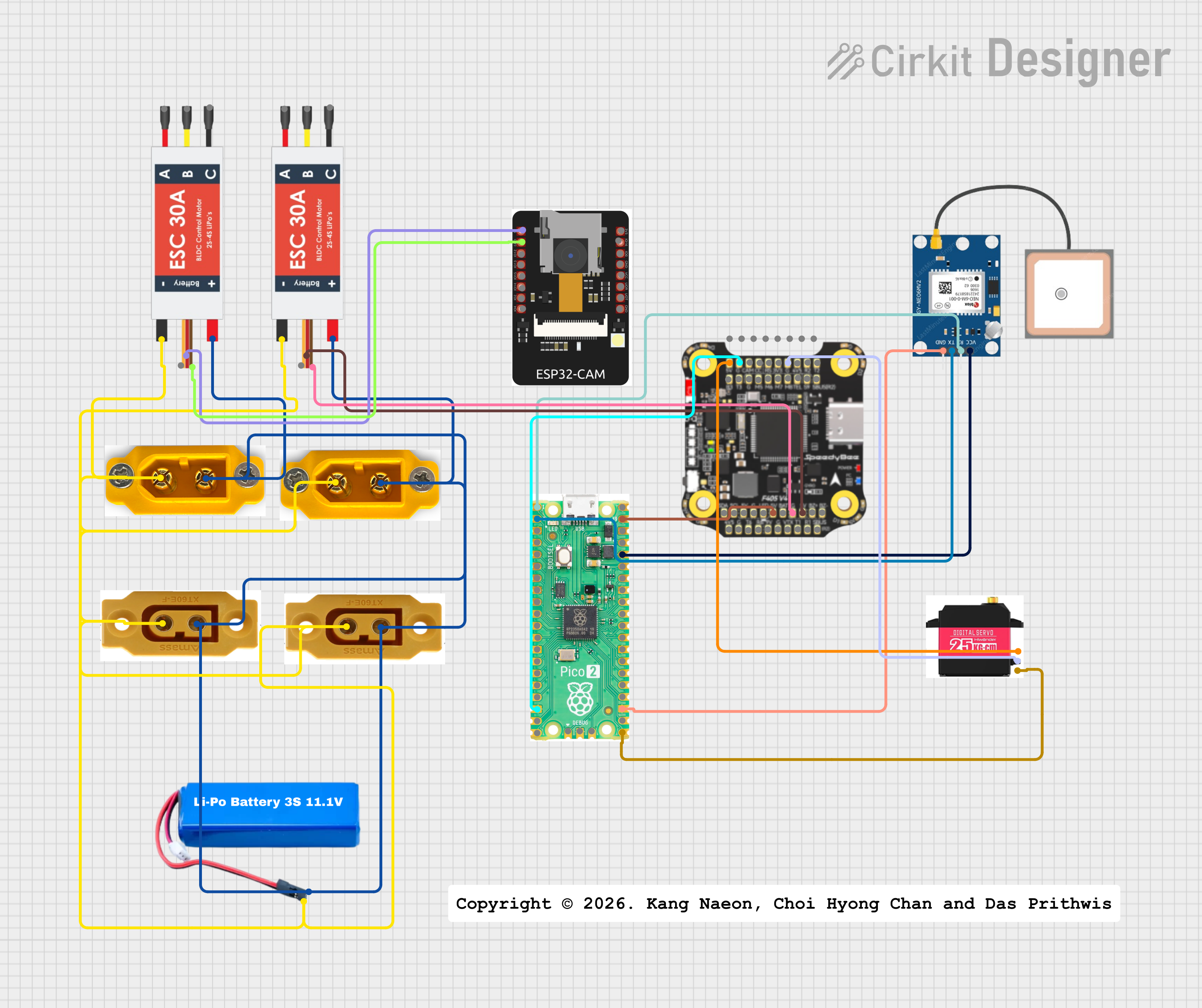
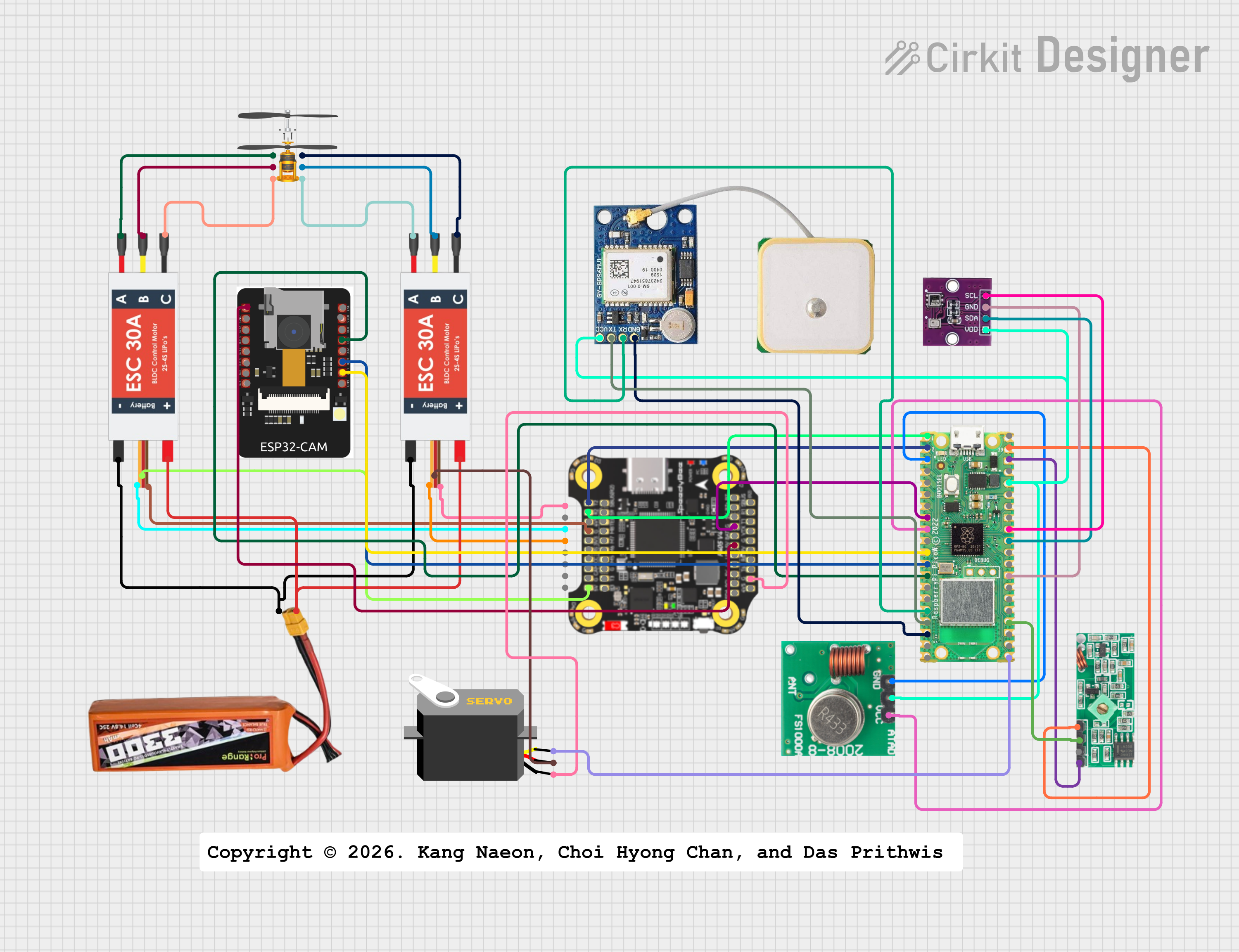
🚁 1️⃣ Drone AI Payload (Edge Sensing Unit)Each drone carries a lightweight AIoT payload module that transforms it into a flying sensor node.
🔧 Hardware ComponentsESP32-CAM (OV2640) → Captures aerial images/video
Raspberry Pi Pico 2W → Controls GPS, servo, and communication
NEO-6M GPS → Provides geolocation tagging
F405 Flight Controller → Integrates with UAV power & telemetry
Servo Motor → Enables physical signaling experiments
LiPo Battery + ESC → Power system
The drone does not perform heavy AI processing — it focuses on data capture and transmission.
Each drone transmits:
- Captured images
- GPS coordinates
- Device ID
These are sent to the ground gateway for centralized processing.
🧠 2️⃣ Jetson Nano Edge Gateway (Fleet Brain)At the center of the system is an NVIDIA Jetson Nano, acting as a multi-device AI gateway.
This is what allows NaeonAIr to scale beyond a single drone.
🚦 Gateway ResponsibilitiesDevice Hub → Manages communication with up to 100 drones simultaneously
Stream Router → Forwards live feeds to monitoring interface
AI Processing Node → Hosts crowd analysis services
IoT Bridge → Sends results to Mobius smart-city platform
Local Decision Layer → Can operate even with limited internet
Instead of every drone running AI, the Jetson Nano provides centralized edge intelligence.
🔄 Hybrid Data Flow ArchitectureTo balance real-time performance and scalable storage, NaeonAIr uses a hybrid communication model.
⚡ Real-Time Monitoring- Gateway ↔ Dashboard via WebSocket
- Provides low-latency live monitoring
Gateway → AI Server : HTTP POST : Sends images for analysis
AI Server → Mobius : HTTP POST : Uploads risk results
Dashboard → Mobius : HTTP GET : Retrieves latest analytics
Instead of sending heavy image files to Mobius:
- AI server stores images locally
- Only image URLs + metadata are uploaded
This prevents overload of the IoT platform and keeps the system scalable.
🤖 3️⃣ AI Crowd Risk Analysis ServerThis server turns drone images into crowd safety intelligence.
A fine-tuned YOLO model detects people from aerial imagery.
Output: Bounding boxes and crowd count.
🌊 Step 2 — Flow & Pressure AnalysisUnlike basic systems that only count people, NaeonAIr analyzes:
- Movement direction of crowd clusters
- Differences in flow between groups
- Zones where motion compresses into resistance
This produces a crowd pressure metric, a key factor in crush risks.
⚠️ Step 3 — Risk Score CalculationThe system combines:
- Crowd count
- Density trends
- Movement flow
- Pressure indicators
Into:
Risk Score (0–100)
Risk Level: SAFE / CAUTION / DANGER
This provides an early warning system, not just statistics.
🌐 4️⃣ Smart City Integration — Mobius (oneM2M)All analysis results are stored in Mobius oneM2M, enabling integration with city-scale systems.
📦 Mobius Data StructureMobius
└── WisDrone
├── crowd_analysis
├── drone_status
└── alertsThis allows:
- Historical analysis
- Multi-system integration
- City-wide monitoring dashboards
The human side of NaeonAIr is a TypeScript-based web dashboard.
This interface acts as a live control and monitoring center.
🎛 Dashboard Features📦 Device Management- Register and monitor multiple drones
- View active/inactive device status
Operators can switch visualization modes:
Density → Shows crowd concentration
Danger → Displays AI-estimated risk
📷 Live Camera StreamsOperators can view real-time drone video feeds.
🌍 3D Map-Based VisualizationRisk data is overlaid on a 3D city map, allowing:
- Spatial understanding of risk zones
- Tracking of crowd movement patterns
- Faster emergency response decisions
Not just numbers — but spatial risk awareness.
Because the system is gateway-based, it can support:
- Up to 100 drone devices
- CCTV cameras
- Fixed smart sensors
- Mobile robots
All follow the same pipeline:
Device → Gateway → AI Analysis → Mobius → Dashboard
⚠️ Safety & Ethical ConsiderationsNaeonAIr is a research and safety-support system.
- Must comply with UAV flight regulations
- Must respect privacy laws
- Designed for crowd safety monitoring, not surveillance misuse
- Supports human decision-makers, not autonomous enforcement
NaeonAIr transforms drones from flying cameras into:
AI-powered, city-scale crowd safety sensors
By combining edge AI, computer vision, IoT integration, and real-time visualization, the system provides a digital twin of crowd risk — enabling faster, smarter, and safer event management.


Choi Hyong Chan, Kang Naeon, Das Prithwis
 Prithwis Das


Comments