
Hardware components | ||||||
 |
| × | 1 | |||
| × | 1 | ||||
| × | 1 | ||||
Software apps and online services | ||||||
 |
| |||||
Thanks to the original author プロフィール for his contribution to this article.
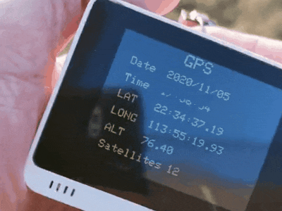
The Wio terminal GPS is really useful for the climber and Hiker when they are going hiking or some high altitude place. Wio terminal GPS can exactly to judge their position via latitude, longitude, and altitude, and the Wio terminal GPS can display the number of satellites connecting to Wio terminal on the first page, on the second page is display the moving speed, course over ground, latitude, and longitude, etc. the third-page is displaying a substantial map to remind you where satellites the direction.
Feature- Location via connecting with satellites
- Wio terminal GPS does not need to connect WIFI or Bluetooth
- Display current date and time and satellites direction
Hardware required
Software required
Wio terminal library
Before you upload the code, you need to download the library to support the code. please check here.
- Install the TinyGPS++.h library
- Install the TFT_eSPI.h library
- Install the Seeed_FS.h library
If you do not know how to install the library please check here.
InstructionThis instruction is to guide you on how to connect the cable and use the Wio terminal GPS.
Connection
This is Wio terminal and Grove - GPS(Air530) connection.
Step 1. Install all the library on your PC.
Step 2. Copy the code stick on the Arduino IDE
Step 3. The GPS interface will display on the Wio terminal
Wio terminal GPS
C/C++#include <SoftwareSerial.h>
#include <TinyGPS++.h>
#include "TFT_eSPI.h"
#include <SPI.h>
#include <Seeed_FS.h>
#include "SD/Seeed_SD.h"
SoftwareSerial mySerial(2, 3); // RX, TX
TinyGPSPlus gps;
TFT_eSPI tft;
TinyGPSCustom ExtLat(gps, "GPGGA", 3); //N for Latitude
TinyGPSCustom ExtLng(gps, "GPGGA", 5); //E for Longitude
const float pi = 3.1415;
int menu = 0, p_menu = 3;
int logging = 0, sat_n = 0;
double dist_LAT = 34.9722899, dist_LONG = 138.3868869;
String p_hour, p_lat, p_lng, p_alt, p_sat, p_date;
String p_my_speed, p_my_course, p_dist_dTo, p_dist_cTo;
String pdist_LAT, pdist_LONG;
String sdist_LAT = String(dist_LAT);
String sdist_LONG = String(dist_LONG);
//for Satellites position ****************************
static const int MAX_SATELLITES = 40;
TinyGPSCustom totalGPGSVMessages(gps, "GPGSV", 1); // $GPGSV sentence, first element
TinyGPSCustom messageNumber(gps, "GPGSV", 2); // $GPGSV sentence, second element
TinyGPSCustom satsInView(gps, "GPGSV", 3); // $GPGSV sentence, third element
TinyGPSCustom satNumber[4]; // to be initialized later
TinyGPSCustom elevation[4];
TinyGPSCustom azimuth[4];
TinyGPSCustom snr[4];
struct
{
bool active;
int elevation;
int azimuth;
int snr;
int dsp;
} sats[MAX_SATELLITES];
int Log_f = 0;
String N_date, hour0;
unsigned long p_time;
int N_y, N_m, N_d;
String hr1, min1, sec1;
String F_name;
bool sd;
// ************************
void disp_title(){
if (menu == 0) {
tft.fillScreen(TFT_BLACK);
tft.setTextSize(3);
tft.drawString("GPS",120,3);
tft.setTextSize(2);
tft.drawString("Date",30,42);
tft.drawString("Time",30,74);
tft.drawString("LAT",30,106);
tft.drawString("LONG",30,138);
tft.drawString("ALT",30,170);
tft.drawString("Satellites",30,202);
if(sd != true) {
tft.drawChar(295,223,'S',TFT_WHITE, TFT_RED,2);
tft.drawChar(307,223,'D',TFT_WHITE, TFT_RED,2);
}
p_hour = " "; p_lat = " "; p_lng = " "; p_alt = " "; p_sat = " "; p_date = " ";
if(Log_f == 1)
tft.drawChar(295,3,'L',TFT_YELLOW, TFT_BLACK,2);
}
else if(menu == 1) {
tft.fillScreen(TFT_BLACK);
tft.setTextSize(3);
tft.drawString("GPS",120,3);
tft.setTextSize(2);
tft.drawString("Speed",30,64);
tft.drawString("Course",30,88);
tft.drawString("Destination",30,112);
tft.drawString("LAT",40,136);
tft.drawString("LONG",40,160);
tft.drawString("Distance",40,184);
tft.drawString("Course",40,208);
tft.fillRect(130,136,120,16,TFT_BLACK);
tft.drawString(sdist_LAT,130,136);
tft.fillRect(130,160,120,16,TFT_BLACK);
tft.drawString(sdist_LONG,130,160);
if(sd != true) {
tft.drawChar(295,223,'S',TFT_WHITE, TFT_RED,2);
tft.drawChar(307,223,'D',TFT_WHITE, TFT_RED,2);
}
p_my_speed = " "; p_my_course = " "; p_dist_dTo = " "; p_dist_cTo = " ";
if(Log_f == 1)
tft.drawChar(295,3,'L',TFT_YELLOW, TFT_BLACK,2);
}
else if(menu == 2) {
tft.fillScreen(TFT_BLACK);
tft.setTextSize(2);
tft.drawCircle(160,120,120,TFT_WHITE);
tft.drawCircle(160,120,80,TFT_WHITE);
tft.drawCircle(160,120,60,TFT_WHITE);
tft.drawCircle(160,120,40,TFT_WHITE);
tft.drawLine(160,1,160,239,TFT_WHITE);
tft.drawLine(40,120,280,120,TFT_WHITE);
tft.fillCircle(160,120,3,TFT_RED);
tft.drawChar(153,0,'N',TFT_ORANGE, TFT_BLACK,3);
tft.drawChar(153,219,'S',TFT_ORANGE, TFT_BLACK,3);
tft.drawChar(24,111,'W',TFT_ORANGE, TFT_BLACK,3);
tft.drawChar(280,111,'E',TFT_ORANGE, TFT_BLACK,3);
if(sd != true) {
tft.drawChar(295,223,'S',TFT_WHITE, TFT_RED,2);
tft.drawChar(307,223,'D',TFT_WHITE, TFT_RED,2);
}
for (int i=0; i<MAX_SATELLITES; ++i)
sats[i-1].dsp = 0;
if(Log_f == 1)
tft.drawChar(295,3,'L',TFT_YELLOW, TFT_BLACK,2);
}
}
// ===================================================================
void setup() {
// Open serial communications and wait for port to open:
Serial.begin(57600);
mySerial.begin(9600);
pinMode(WIO_KEY_A, INPUT_PULLUP);
pinMode(WIO_KEY_B, INPUT_PULLUP);
pinMode(WIO_KEY_C, INPUT_PULLUP);
Serial.print("Initializing SD card...");
if (!SD.begin(SDCARD_SS_PIN, SDCARD_SPI)) {
Serial.println("initialization failed!");
//while (1);
sd = false;
tft.drawChar(295,223,'S',TFT_WHITE, TFT_RED,2);
tft.drawChar(307,223,'D',TFT_WHITE, TFT_RED,2);
}
else {
Serial.println("initialization done.");
sd = true;
}
tft.begin();
tft.setRotation(3);
tft.fillScreen(TFT_BLACK); //Black background
tft.setTextColor(TFT_YELLOW);
//for satellites position
// Initialize all the uninitialized TinyGPSCustom objects
for (int i=0; i<4; ++i)
{
satNumber[i].begin(gps, "GPGSV", 4 + 4 * i); // offsets 4, 8, 12, 16
elevation[i].begin(gps, "GPGSV", 5 + 4 * i); // offsets 5, 9, 13, 17
azimuth[i].begin( gps, "GPGSV", 6 + 4 * i); // offsets 6, 10, 14, 18
snr[i].begin( gps, "GPGSV", 7 + 4 * i); // offsets 7, 11, 15, 19
}
}
// ============================================================================
void loop() {
long N_mjd;
while (mySerial.available() > 0) {
char c = mySerial.read();
//Serial.print(c);
gps.encode(c);
}
if (((millis()-p_time) >3000) and (Log_f ==1)) {
File myFile = SD.open(F_name,FILE_APPEND);
if(myFile) {
myFile.print(N_date);
Serial.print(N_date);
myFile.print(",");
Serial.print(" , ");
myFile.print(hour0);
Serial.print(hour0);
myFile.print(",");
Serial.print(" , ");
myFile.print(gps.location.lat(),6);
Serial.print(gps.location.lat(),6);
myFile.print(",");
Serial.print(" , ");
myFile.print(gps.location.lng(),6);
Serial.print(gps.location.lng(),6);
myFile.print(",");
Serial.print(" , ");
myFile.println(gps.altitude.meters());
Serial.println(gps.altitude.meters());
myFile.close();
}
p_time = millis();
}
double lat0 = gps.location.lat();
double lat1 = (lat0 -int(lat0))*60;
double lat2 = (lat1 - int(lat1))*60;
String lat3 = String(int(lat0))+':' + String(int(lat1))+':'+String(lat2) + ' ' + String(ExtLat.value());
double lng0 = gps.location.lng();
double lng1 = (lng0 -int(lng0))*60;
double lng2 = (lng1 - int(lng1))*60;
String lng3 = String(int(lng0))+':' + String(int(lng1))+':'+String(lng2) + ' ' + String(ExtLng.value());
int hr = gps.time.hour()+9;
if (hr>24) hr -= 24;
String hr0 = '0'+String(hr);
hr1 = hr0.substring(hr0.length()-2);
String min0 = '0'+String(gps.time.minute());
min1 = min0.substring(min0.length()-2);
String sec0 = '0'+String(gps.time.second());
sec1 = sec0.substring(sec0.length()-2);
hour0 = hr1+':'+min1+':'+sec1;
//Calculate date
if (gps.date.isUpdated()) {
int y = gps.date.year();
int m = gps.date.month();
int d = gps.date.day();
if(m<3){y--; m+=12;}
long mjd = int(361.7015*y)+int(y/400)-int(y/100)+int(30.59*(m-2))+d-678912;
if(gps.time.hour()>14)
N_mjd = 58580+(mjd-51412);
else
N_mjd = 58579+(mjd-51412);
long n = N_mjd+678881;
long a = 4*n+3+3*(4*(n+1)/146097+1);
long b = 5*((a % 1461)/4)+2;
N_y = int(a/1461);
N_m = int(b/153+3);
N_d = int((b % 153)/5+1);
if (N_m>12){N_y++; N_m-=12;}
N_date = String(N_y)+'/'+('0'+String(N_m)).substring(('0'+String(N_m)).length()-2)+'/'+('0'+String(N_d)).substring(('0'+String(N_d)).length()-2);
}
if(menu == 0) { //menu 0: Location -----------------------------
if(menu != p_menu) {
disp_title();
p_menu = menu;
}
if (N_date != p_date) { //Date
tft.fillRect(100,42,120,16,TFT_BLACK);
tft.drawString(N_date,100,42);
p_date = N_date;
}
if (hour0 != p_hour) { //Time
tft.fillRect(100,74,120,16,TFT_BLACK);
tft.drawString(hour0,100,74);
p_hour = hour0;
}
if (lat3 != p_lat) { //Latitude
tft.fillRect(100,106,132,16,TFT_BLACK);
tft.drawString(lat3,100,106);
p_lat = lat3;
}
if (lng3 != p_lng) { //Longitude
tft.fillRect(100,138,156,16,TFT_BLACK);
tft.drawString(lng3,100,138);
p_lng = lng3;
}
if (String(gps.altitude.meters()) != p_alt) { //Altimeter
tft.fillRect(100,170,60,16,TFT_BLACK);
tft.drawString(String(gps.altitude.meters()),100,170);
p_alt = String(gps.altitude.meters());
}
if (String(gps.satellites.value()) != p_sat) { //N of Satellites
tft.fillRect(160,202,32,16,TFT_BLACK);
tft.drawString(String(gps.satellites.value()),160,202);
p_sat = String(gps.satellites.value());
}
} // end of menu=0
else if (menu == 1) { //menu1: Speed ---------------------------
if(menu != p_menu) {
disp_title();
p_menu = menu;
}
String my_speed = String(gps.speed.mps());
String my_course = String(gps.course.deg());
double dist_dTo =
TinyGPSPlus::distanceBetween(
gps.location.lat(),
gps.location.lng(),
dist_LAT,
dist_LONG);
double dist_cTo =
TinyGPSPlus::courseTo(
gps.location.lat(),
gps.location.lng(),
dist_LAT,
dist_LONG);
String s_distanceTo = String(dist_dTo);
String s_courseTo = String(dist_cTo);
//Display Speed & Course
if (my_speed != p_my_speed) { //Speed
tft.fillRect(130,64,48,16,TFT_BLACK);
tft.drawString(my_speed,130,64);
p_my_speed = my_speed;
}
if (my_course != p_my_course) { //Course
tft.fillRect(130,88,72,16,TFT_BLACK);
tft.drawString(my_course,130,88);
p_my_course = my_course;
}
if (sdist_LAT != pdist_LAT) { //distination latitude
tft.fillRect(130,136,120,16,TFT_BLACK);
tft.drawString(sdist_LAT,130,136);
pdist_LAT = sdist_LAT;
}
if (sdist_LONG != pdist_LONG) { //distination longitude
tft.fillRect(130,160,120,16,TFT_BLACK);
tft.drawString(sdist_LONG,130,160);
pdist_LONG = sdist_LONG;
}
if (s_distanceTo != p_dist_dTo) { //distance to the mark point
tft.fillRect(154,184,84,16,TFT_BLACK);
tft.drawString(s_distanceTo,154,184);
p_dist_dTo = s_distanceTo;
}
if (s_courseTo != p_dist_cTo) { //Course to the mark point
tft.fillRect(154,208,72,16,TFT_BLACK);
tft.drawString(s_courseTo,154,208);
p_dist_cTo = s_courseTo;
}
} //end of menu = 1
if (menu == 2) { //menu 2: Satellites ---------------------------
if(menu != p_menu) {
disp_title();
p_menu = menu;
}
if (totalGPGSVMessages.isUpdated())
{
for (int i=0; i<4; ++i) {
int no = atoi(satNumber[i].value());
if (no >= 1 && no <= MAX_SATELLITES)
{
sats[no-1].elevation = atoi(elevation[i].value());
sats[no-1].azimuth = atoi(azimuth[i].value());
sats[no-1].snr = atoi(snr[i].value());
sats[no-1].active = true;
}
}
int totalMessages = atoi(totalGPGSVMessages.value());
int currentMessage = atoi(messageNumber.value());
if (totalMessages == currentMessage)
{
for (int i=0; i<MAX_SATELLITES; ++i)
{
if (sats[i].active)
{
int p_X = 160 + (120*cos((sats[i].elevation/180.0)*pi)) * (sin((sats[i].azimuth)/360.0*2.0*pi));
int p_Y = 120 - (120*cos((sats[i].elevation/180.0)*pi)) * (cos((sats[i].azimuth)/360.0*2.0*pi));
tft.fillCircle( p_X, p_Y, 5,TFT_BLUE);
if (sats[i].dsp == 0) {
tft.drawString(String(i+1),p_X+3,p_Y+3);
sats[i].dsp = 1;
}
}
}
for (int i=0; i<MAX_SATELLITES; ++i)
sats[i].active = false;
}
}
} //end of menu = 2
// Button check
if (digitalRead(WIO_KEY_C) == LOW) { // Page(menu) change
menu++;
if(menu > 2) menu = 0;
while(digitalRead(WIO_KEY_C) == LOW){}
}
if (digitalRead(WIO_KEY_A) == LOW) { // Log to SD card
if ((Log_f == 0) and (sd == true)) {
Log_f = 1;
tft.drawChar(295,3,'L',TFT_YELLOW, TFT_BLACK,2);
p_time = millis();
if(N_date !="" and hour0 !="") {
F_name = String(N_y)+String(N_m)+String(N_d)+"_"+hr1+min1+sec1+".txt";
Serial.println(F_name);
}
}
else if ((Log_f == 1) and (sd == true)){
Log_f = 0;
tft.drawChar(295,3,'L',TFT_BLACK, TFT_BLACK,2);
Serial.println(F_name+" closed");
}
while(digitalRead(WIO_KEY_A) == LOW){}
}
if (digitalRead(WIO_KEY_B) == LOW) { // Mark current location
dist_LAT = gps.location.lat();
dist_LONG = gps.location.lng();
tft.drawChar(308,3,'M',TFT_YELLOW, TFT_BLACK,2);
while(digitalRead(WIO_KEY_B) == LOW){}
}
} // end of loop


Comments