


Hardware components | ||||||
 |
| × | 1 | |||
| × | 1 | ||||
| × | 1 | ||||
 |
| × | 1 | |||
| × | 1 | ||||
Software apps and online services | ||||||
 |
| |||||
Hey World!
I love traveling. But I don't like stopping to take pictures. But I STILL want pictures. So I decided to make my own Personal Automated GPS Controlled Portable Photo Taker!
This project is a backpack that takes pictures when I am close to places that I've pre-selected. And what better place to test it than in London?
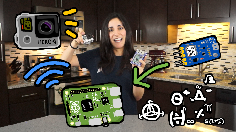
The HardwareI hooked up a GPS module to a Raspberry Pi (powered by a battery pack) which sends signals through WiFi to a GoPro.
- GPS: No soldering today! I just plugged the GPS module to the Raspberry Pi vis USB.
- WiFi: I turned on the WiFi of the GoPro and connected the Raspberry Pi to it. The WiFi SSD is configured by the GoPro App.
- Raspberry Pi: I plugged it to the battery pack.
All set! You can add the GoPro Arm to anything you’d like! I chose a backpack to use when I travel.
The SoftwareI compiled a list of coordinates of the places I wanted to visit in London. Then I wrote a script in Python (LondonGPS.py) to calculate the distance between the coordinates I am at and the coordinates of my pre-selected locations.
The script runs on startup in my Raspberry Pi so it can start running the script and checking my coordinates as soon as I turn on the battery pack.
GoProI found this AWESOME GoPro API Library, and used it to connect my GoPro with my Raspberry Pi through WiFi. First, to get API working I installed python3. Then I installed the library through pip:
pip install goprocam
Then, in the LondonGPS.py script I initialized the camera:
camera = GoProCamera.GoPro()
And to take pictures:
#0 is the time it waits before the picture is taken.
camera.take_photo(0)
GPS:
I installed gpsd-py3 through pip. To get the gpsd installed and started I followed this: https://pypi.python.org/pypi/gpsd-py3/0.2.0.
Then I pointed the gps daemon to the GPS device. On my Pi, I edited the file /etc/rc.local and added the following line:
gpsd /dev/ttyACM0 -F /var/run/gpsd.sock
In the same file on my Pi /etc/rc.local I added the command to run my script.
python3 /home/pi/LondonGPS.py
All the calculations are made in the python script attached below.
Check it out and make your own PERSONAL AUTOMATED GPS CONTROLLED PORTABLE PHOTO TAKER!
Comment below what you think and which places you would add! Don't forget to subscribe to my YouTube channel to be the first to know when the new videos are out: https://www.youtube.com/c/estefanniegg.


Comments